Measuring distance
This resource focuses on how to use a scale on a map for measuring distance in a straight line, or ‘as the crow flies’. It is a simple resource on distance measurement that helps students to understand how to convert distances on maps to real-life distances, making it ideal for practising numerical skills at key stage 3 as well as map skills.
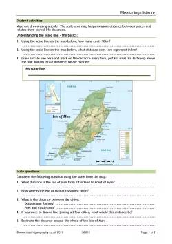
Students complete a series of activities using a map of the Isle of Man, converting centimetres to kilometres. Teaching notes with answers are included within the resource.
An extract from the worksheet:
2. How wide is the Isle of Man at its widest point?
3. What is the distance between the cities:
- Douglas and Ramsey?
- Peel and Castletown?
4. If you were to draw a line joining all four cities, what would this distance be?
All reviews
Have you used this resource?
Review this resource30/09/2018
20/08/2018
25/07/2018
