Mapping the UK with triangles
Download this resource for free
Create an account to access thousands of teacher-created PDFs.
No payment required!
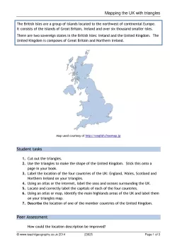
A student activity designed to develop an understanding of the spatial parameters of the UK. Students are encouraged to use atlases in a productive and independent manner to complete the activity where simplified triangles are used to show the shape of and locate places within the UK.
Also included are a PowerPoint showing two examples of students' work, and teaching notes to extend students' understanding of both legal and geographical distinctions using the Euler diagram.
All reviews
Have you used this resource?
Review this resource16/09/2020
Planning to use this as an activity for students to use at home. They can print the triangles or draw them if they don't have a printer. Thanks!
26/06/2020
28/04/2020
28/04/2020
12/06/2019
06/10/2018
21/09/2018
